

Imagine transforming your smartphone into a powerful tool for land surveying. Yes, you can!
You don’t need expensive equipment or specialized knowledge anymore. Your phone can do the job with surprising accuracy. Whether you’re a homeowner wanting to measure your property or a budding developer scouting new land, this guide is for you. You’ll learn how to leverage your smartphone’s capabilities to survey land easily and effectively.
Get ready to unlock the potential of technology you already have in your pocket, and discover the convenience and efficiency of modern land surveying techniques. You’ll wonder how you ever managed without it! Keep reading to find out how simple it is to get started.
Choosing The Right App
Choosing the right app for surveying land with a smartphone simplifies the process. Look for features like GPS accuracy and ease of use. Ensure compatibility with your device and budget-friendly options for the best experience.
Choosing the right app to survey land with your smartphone can transform a potentially complex task into a manageable and even enjoyable experience. With so many apps available, it might feel like an overwhelming choice. However, understanding your specific needs and the features each app offers can guide you toward the best decision. Why not make land surveying as easy as clicking a few buttons on your phone?Top Survey Apps Available
Several apps stand out when it comes to land surveying. GPS Fields Area Measure offers precision by allowing you to measure distances and areas using your smartphone’s GPS. Land Surveyor provides tools for parcel measurements and mapping, making it ideal for professionals and hobbyists alike. Surveying Calculator is another great choice, offering more technical features for those who need detailed calculations.Features To Consider
Choosing the right app is more than just picking the most popular one. Consider what features are most important for your needs. If accuracy is key, look for apps with high-precision GPS capabilities. Need to share your findings? Opt for apps with easy export options. Ease of use is another crucial factor. An app with a user-friendly interface can save you time and frustration. Also, check if the app offers offline functionality, especially if you’re surveying in remote areas without internet access. Have you thought about how much you’re willing to spend? Some apps are free with basic features, while others require a subscription for advanced tools. In the end, the right app should feel like a seamless extension of your workflow. Consider trying a few to see which one fits best with your style and needs. What features can’t you live without when surveying land?Preparing Your Smartphone
Getting ready to survey land with your smartphone involves more than just downloading an app. You need to ensure your device is fully equipped to handle the task. This preparation can make or break your surveying experience, affecting both accuracy and efficiency.
Ensuring Gps Accuracy
Accurate GPS is crucial for reliable land surveying. Before you head out, check your smartphone’s location settings. Turn on high accuracy mode to use GPS, Wi-Fi, and mobile networks together for the best results.
Apps like Google Maps can help you verify your GPS accuracy. Use them to see how precisely your device pinpoints your location. If you find discrepancies, consider calibrating your GPS or using an external GPS receiver for enhanced precision.
Battery And Storage Management
Your smartphone’s battery life can limit your surveying time. Start with a full charge and carry a portable charger. This simple step can save you from abrupt interruptions during your survey.
Storage is another concern, especially if you’re collecting large amounts of data. Clear unnecessary files and apps to free up space. Use cloud storage options to keep your data safe without consuming your phone’s storage.
How do you handle unexpected low battery or storage warnings when you’re in the middle of nowhere? Planning ahead with power banks and cloud backups can keep these issues at bay.
By focusing on these preparations, your smartphone transforms from a simple device into a powerful tool for land surveying. Are you ready to elevate your surveying game?
Setting Up The Survey Area
Smartphones make surveying land easy. First, choose a location and open your survey app. Use the app to mark boundaries and record data. Ensure your device’s GPS is accurate for precise measurements.
Setting up the survey area with your smartphone can be a surprisingly straightforward task. With the right apps and a clear understanding of your land’s features, you can efficiently map out your property. Whether you’re a landowner or a hobbyist, modern technology makes surveying more accessible than ever. Imagine the convenience of having detailed land data right at your fingertips.Defining Boundaries
Accurate boundary definition is crucial for a successful survey. Start by identifying the outer edges of your property using GPS apps on your smartphone. Many apps provide satellite imagery, which can help you visualize your land’s borders. Consider walking the perimeter to confirm these boundaries physically. This hands-on approach not only ensures accuracy but also familiarizes you with your land’s landscape. Ask yourself, do these boundaries align with your expectations? If discrepancies arise, consult local records to verify property lines.Marking Key Points
Marking key points is the next step in setting up your survey area. Use your smartphone to pinpoint important landmarks or features within your property. These might include trees, rocks, or water sources. Utilize apps that allow you to drop pins on these locations. This digital trail can serve as a reference when reviewing your survey data later. Think about which features are most significant for your purposes. Are they visible in satellite images, or will you need to mark them manually on-site? By thoughtfully defining boundaries and marking key points, you can create a comprehensive map of your land. Embrace the process as an opportunity to connect with your property and gain valuable insights.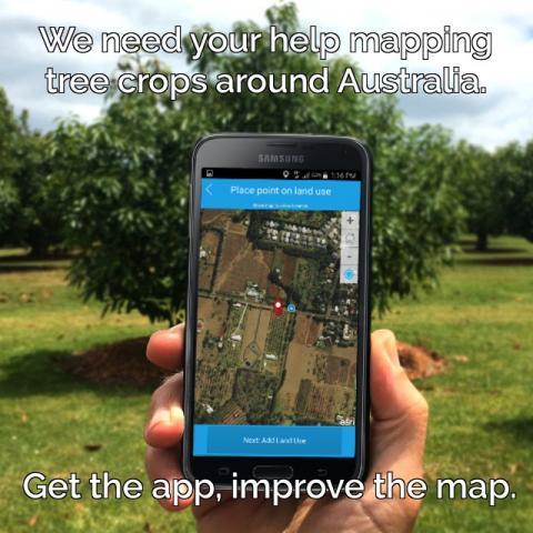
Credit: www.agriculture.gov.au
Conducting The Survey
Smartphones offer a convenient way to survey land. Use GPS apps for accurate measurements and mapping. Capture images to document terrain details.
Conducting a land survey with your smartphone might sound like a modern miracle, but it’s entirely feasible and increasingly practical. Gone are the days when land surveying required bulky equipment and specialized skills. Now, with the right apps and a bit of know-how, your smartphone can become a powerful tool in land measurement and mapping. Let’s dive into the essential steps of conducting a survey, focusing on capturing GPS data and using augmented reality features.Capturing Gps Data
Accurate GPS data is the backbone of any successful land survey. Your smartphone is equipped with a GPS chip that can help you pinpoint your exact location. Ensure your GPS is turned on and that you are in an area with a clear view of the sky to improve accuracy. Apps like Google Maps or specialized surveying apps can help capture precise coordinates. When I first tried this, I was amazed at how quickly and easily I could gather data. However, remember that the quality of GPS data can vary based on your phone model and environmental conditions. To enhance accuracy, consider using an external GPS receiver that connects to your smartphone. These devices can provide more precise readings, especially in challenging terrains. Have you ever wondered how accurate your phone really is? Testing it against an external device might surprise you.Using Augmented Reality Features
Augmented reality (AR) is not just for gaming. It’s also a game-changer for land surveying. Some apps use AR to overlay information directly onto your camera view, helping you visualize boundaries and landmarks. Imagine standing on your property and seeing virtual boundary lines through your phone’s camera. This visualization can provide a clear understanding of the land layout. During my first experience with AR in surveying, I found it incredibly intuitive and engaging. Ensure you have a compatible device and the latest version of your chosen app. AR features can sometimes be resource-heavy, so a modern smartphone will offer the best experience. Have you tried using AR for any other purposes? It could be an eye-opener for how technology can simplify complex tasks. Conducting a land survey with your smartphone is an empowering experience. With GPS data and AR features at your fingertips, you can confidently tackle the task. What other areas of your life could benefit from a tech upgrade?Analyzing Survey Data
Surveying land with a smartphone is now accessible for everyone. Modern apps offer tools to measure and map land accurately. These tools help users collect data efficiently, saving time and effort.
Analyzing survey data effectively is the heart of any successful land surveying project. With a smartphone in hand, you can gather data in the field, but the real magic happens when you analyze that data to generate actionable insights. This involves understanding how to manage, interpret, and present your findings in a way that’s both clear and useful.Importing Data To Software
Once you’ve collected your survey data using your smartphone, the next step is to import it into a software program that can handle geographic data. Apps like ArcGIS or QGIS are popular choices because they offer robust tools for data analysis and visualization. Begin by connecting your smartphone to your computer and transferring the data files. Most survey apps will export data in formats like CSV or KML, which are compatible with these programs. Once the data is imported, you’ll be able to manipulate it more effectively. Have you ever considered how much time you can save by setting up templates in your software? Templates can automate repetitive tasks, ensuring consistency across projects. This approach not only saves time but also reduces errors.Creating Maps And Reports
Transforming raw data into insightful maps and reports is crucial for understanding the terrain and making informed decisions. Start by selecting the layers of data that are most relevant to your project. This could be anything from elevation to vegetation cover, depending on your needs. Creating a map is not just about plotting points; it’s about telling a story. Use colors and symbols effectively to highlight important features. A well-designed map can communicate complex information at a glance. Reports are equally important. They provide a written record of your findings and can include tables, charts, and narrative explanations. Consider how your audience will use this information and tailor your reports to meet their needs. A clear, concise report can make all the difference in project approval or funding. Have you experienced the frustration of presenting data that no one understands? Clear maps and reports can eliminate that confusion, making your work more impactful and appreciated. Remember, the goal is to make the data work for you, not the other way around.
Credit: www.engineersupply.com
Ensuring Accuracy And Reliability
Smartphone apps make land surveying more accurate and reliable. GPS features help pinpoint exact locations. Easy-to-use tools ensure precise measurements, reducing errors.
Ensuring accuracy and reliability in land surveying with a smartphone is crucial for achieving precise results. While technology simplifies the process, it’s essential to adopt practices that minimize errors and enhance trust in the data collected. Your smartphone can be a powerful tool, but it requires careful handling and cross-verification to ensure the integrity of the information you gather.Cross-verification Methods
One key to accurate surveying is cross-verifying your data. Use multiple apps to measure the same coordinates and compare results. This helps identify discrepancies and ensures consistency. Consider integrating traditional methods like tape measurements for short distances to confirm the smartphone’s accuracy. If discrepancies arise, it might be an indicator to recalibrate your device or question the app’s precision. Do you have access to professional surveying equipment? Use it to cross-check your smartphone data. While it might be less convenient, it can validate your results.Common Errors And Solutions
Smartphones are prone to common errors like GPS drift or signal loss. You might notice inaccuracies when your GPS signal weakens. To combat this, survey in clear areas with minimal obstructions. Are you experiencing variable readings? Calibrate your device regularly. Check for app updates that might improve accuracy. Another solution is surveying during optimal weather conditions. Rain or heavy clouds can interfere with GPS signals, leading to errors. Ensure you survey in clear weather for the best results. Ensuring accuracy and reliability isn’t just about the tools you use; it’s about the methods you employ and your commitment to precision. How do you ensure your survey data remains trustworthy?Legal And Ethical Considerations
Surveying land with a smartphone is a game-changer, offering convenience and accessibility. However, it’s crucial to navigate the legal and ethical landscape to ensure your surveying activities are above board. Understanding the rules and respecting privacy are key to conducting ethical surveys.
Understanding Local Regulations
Before you start surveying land, check the local regulations in your area. Many regions have specific laws governing land surveys, and ignoring them could lead to fines or legal issues.
Consult local government websites or offices to understand the requirements. You might need permits or approvals, especially for larger projects.
These rules are in place to protect property rights and environmental concerns. Knowing them helps you conduct surveys legally and ethically.
Respecting Privacy
Privacy is a sensitive issue when surveying land, especially if you’re near residential areas. Always respect the privacy of property owners and neighbors.
Avoid capturing images or data that aren’t necessary for your survey. If your smartphone captures personal information, such as photos of people or private properties, delete them promptly.
Consider how you would feel if someone surveyed your property without permission. Respecting privacy builds trust and ensures your surveying activities are ethically sound.
Are you confident that your surveying approach respects both legal and ethical standards? Taking the time to understand and implement these considerations can make all the difference.
Credit: www.nestforms.com
Future Of Mobile Land Surveying
The future of mobile land surveying is unfolding right in front of us, transforming how we interact with the world. Imagine holding the power of a traditional surveyor’s toolkit in the palm of your hand. Smartphones are rapidly evolving to include advanced features that make land surveying more accessible, precise, and efficient. This shift is not just about convenience; it’s about revolutionizing the industry and making it more adaptable to modern needs.
Technological Advancements
Smartphones are now equipped with powerful GPS and various sensors, bringing precision to land surveying tasks. Enhanced camera capabilities allow for detailed imagery, which can be crucial for accurate measurements. Consider how augmented reality (AR) apps overlay real-time data onto your screen, providing an intuitive experience for visualizing land plots.
Software applications tailored for surveying are increasingly available. These apps offer tools for mapping, measuring, and analyzing land, all within your phone. You can easily share data with colleagues or clients, streamlining communication and decision-making processes. The integration of cloud technology ensures that your data is backed up and accessible from anywhere.
Potential Challenges
Despite these advancements, there are hurdles to overcome. Data accuracy can be a concern, especially in dense urban areas where GPS signals might be obstructed. You may find that some features require a steep learning curve, as not all users are familiar with technical surveying principles.
Battery life and storage capacity are practical considerations. Long surveying sessions may deplete your smartphone’s battery quickly, and large data files can fill up storage space. Furthermore, reliance on mobile networks can be problematic in remote locations, affecting real-time data transmission.
How will these challenges shape the future of mobile land surveying? Will traditional methods become obsolete, or will there be a harmonious blend of old and new techniques? Your insights and experiences can contribute to this evolving narrative.
Frequently Asked Questions
Can I Survey Land Using My Smartphone?
Yes, you can survey land using your smartphone. Modern apps and GPS technology make it possible to map and measure land accurately. These tools are user-friendly and suitable for basic surveying tasks. Ensure your smartphone has a good GPS sensor for best results.
Which App Is Best For Land Surveying?
There are several top apps for land surveying. Some popular choices include Land Surveyor, Map Pad, and SurveyCam. These apps offer features like GPS mapping, area measurement, and data export. Choose an app that fits your specific surveying needs and is compatible with your smartphone.
How Accurate Is Smartphone Land Surveying?
Smartphone land surveying can be quite accurate but not as precise as professional equipment. Accuracy depends on GPS quality, app features, and environmental conditions. For detailed surveys, specialized tools are recommended. For general purposes, smartphones provide a convenient and cost-effective solution.
What Features Should A Surveying App Have?
A good surveying app should offer GPS mapping, area measurement, and data export options. It should be user-friendly and compatible with your device. Look for apps that provide real-time location tracking and are regularly updated. These features enhance accuracy and usability.
Conclusion
Smartphones make land surveying accessible. No need for expensive tools. Just download an app, and start measuring. Technology simplifies the process. Accurate measurements are possible. Beginners can navigate features with ease. Professional results are achievable with practice. These devices enhance efficiency and save time.
Try surveying with your smartphone today. Discover the convenience of digital tools. A modern approach to land surveying. It’s straightforward and effective. Perfect for small projects or personal use. Embrace technology in land surveying. Your smartphone is a valuable tool.
Make surveying easy and efficient.